
The Peak District Millstone
Millstones have a long history spanning many thousands of years. Their current basic form can be dated to before the Norman Conquest (1066) as corn mills are recorded in Domesday Book of 1086.
The Peak District has a close connection with millstones. They are part of the cultural heritage that is recognised and protected as part of Peak District National Park work. The first reference to millstone production in Derbyshire is as early as the 13th century, at Alderwasley. There are also records of millstones been quarried in Hathersage and Baslow in the 14th and 15th centuries.
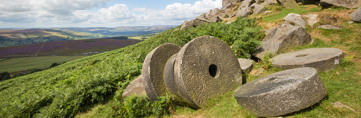
The millstone as you would expect has changed over the centuries. The mushroom-shaped conical stone is an earlier shape that appears to be peculiar to this area and may be Medieval in origin. The more familiar wheel-like cylinder shape was produced in the 18th and 19th centuries. These millstones were used to grind grain like oats, barley and rye or other feedstuffs.
For milling wheat, millstones were imported from Cologne (Cullen stone) in the 18th and 19th centuries but this dark Rhenish lava discoloured the flour. French Burr stones were increasingly imported from the Marne valley, France, as the quartz didn't discolour white flour.
Grindstones were also produced in the Peak District. Mounted vertically on their edges they were used for crushing wood to create wood pulp to make paper. Smaller, thinner stones were used in the edge-tool industry and smaller ones still in cutlery manufacture.
Boundary Markers
It is no accident that the more familiar wheel-shaped millstone is used by us as a key visual element in promoting the Peak District National Park. The millstone features in our boundary markers on key gateway routes into the national park, it also features in our logo.
We are currently exploring ways to maintain, increase and build on our boundary signs.
Map of Peak District Boundary Markers
This map contains the approximate location of major Peak District boundary markers (which come in a number of forms). Due to the size and scale of the National Park, we are unable to provide a more detailed map.
Whilst the National Park Authority assists in maintaining boundary markers, they may be sited on private land.