
Upper Derwent Valley Woodlands Regeneration Management Plan
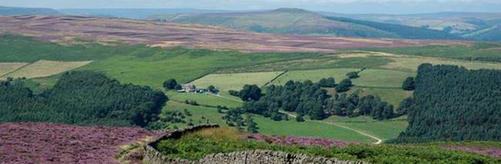
The Upper Derwent Valley is an attractive wooded valley cutting into the surrounding high moorland plateau and containing the impounded headwaters of the River Derwent. A chain of three reservoirs supply drinking water to Sheffield, Derby, Nottingham and Leicester. Enclosed farmland occupies the lower land around the reservoirs, with woodland (mostly coniferous) dominating the steeper slopes.
This pleasing mix of natural and man-made features provides a popular focus for visitors who come from surrounding towns and cities, especially Sheffield which is only eight miles away. The majority of the land belongs to three major landowners - the National Trust, Severn Trent Water and the Forestry Commission.
In 1980 an officer group was formed and produced a management plan for the area to improve recreation opportunities, co-ordinate conservation action and minimise impact on the resident population. Many of its proposals were implemented and include:
- 6.5 miles of "traffic-free"roads (except for access and disabled people)
- clearway order to prevent parking on Derwent Lane
- connecting bus services from surrounding cities, towns and Bamford rail station
- minibus service from Fairholmes to King's Tree when the road is closed
- 7 new and improved car parks and lay-bys
- removal of 3 miles of unsightly roadside fencing and introduction of cattle grids to allow open grazing
- many miles of new or improved routes for walkers, cyclists, horseriders and disabled people
- at Fairholmes, the main car park, a ranger base, information centre, refreshment kiosk and cycle hire centre
- jointly funded ecological, archaeological and visitor surveys
- improvements to nature conservation and landscape interest
- co-ordinated interpretation provision
- an award-winning scheme to protect birds of prey and promote interest
- guidelines and co-ordinated responses to proposed large-scale events in the valley
Several awards have been received for the partnership work carried out in the valley.
The Upper Derwent Valley Woodlands Regeneration Project builds on this work to develop a common management approach to conserving and enhancing the important wooded landscape of the valley.
It contains a Conservation Management Plan which will enable the landowners to better integrate their forestry proposals and improve the biodiversity of the area whilst conserving or improving existing ecological and archaeological features.
It also contains an Access and Audience Development Plan to determine how visitors and local people can understand, celebrate and cherish the woodlands of the Upper Derwent Valley.
A Training Plan suggests training needs to support the implementation of the other two plans.
As well as a management tool, it is hoped this new plan will aid future funding bids to enable the proposals to be fully implemented.
Upper Derwent Valley Woodlands Regeneration Project Management Plan (5.9MB)
Section A - Conservation Management Plan (920KB)
Section B - Audience and Access Development Plan (470KB)
Audience and Access Development Plan - Appendices (690KB)
Audience and Access Development Plan - Map 1 Access proposals (7.4MB)
Section C - Training Plan (145KB)
Section D - Project Proposals and Cost Estimates (135KB)
Map 1 Major Land Ownership (7.5MB)
Map 2 Conservation designations (7.5MB)
Map 3 Existing Woodland Habitats (5.3MB)
Map 4 Vision Map (5.5MB)
Map 5 Design Concept (7.6MB)
Map 6 Native woodland restoration and creation (5.4MB)
Map 7 Felling proposals (5.2MB)